


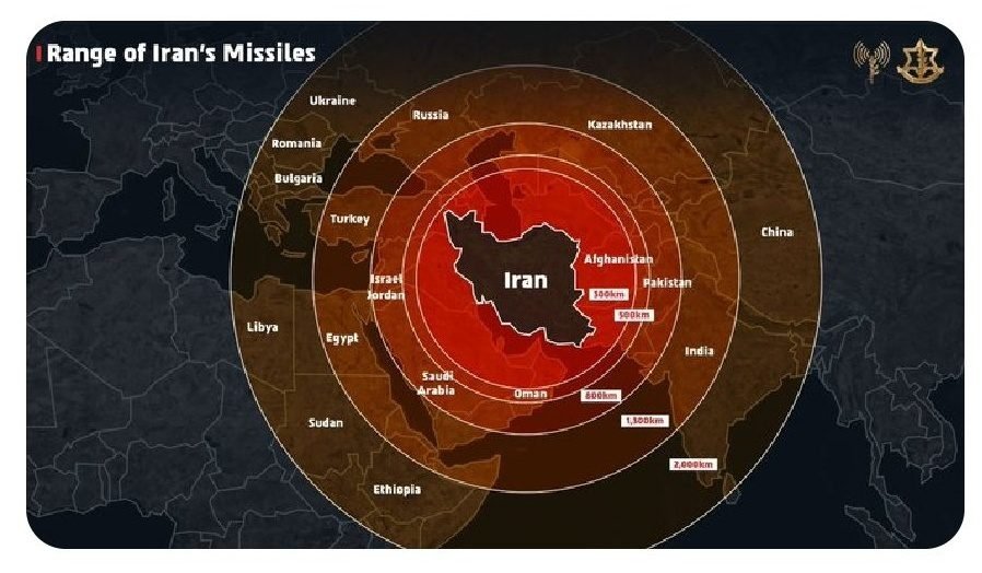
New Delhi/Jerusalem, June 14 — The Israel Defense Forces (IDF) on Friday found itself at the centre of a diplomatic controversy after publishing a map on social media that erroneously depicted Jammu & Kashmir as part of Pakistan. The graphic, intended to showcase the regional reach of Iranian missiles amid rising hostilities in West Asia, drew immediate and widespread criticism from Indian users.
The post, shared from the IDF’s official X (formerly Twitter) account, described Iran as a “global threat” and claimed that Israel “had no other choice but to act.” The accompanying visual used concentric circles to illustrate the purported range of Iran’s missile capabilities across Asia, Europe, and Africa. However, it was the incorrect delineation of India’s territorial boundaries — notably, showing Jammu & Kashmir outside Indian sovereignty — that provoked an online backlash.
Many Indian users took to social media to express their disapproval, with several tagging Israeli Prime Minister Benjamin Netanyahu and urging the IDF to retract and amend the post. “Forget precision, it’s no way near the truth,” one user wrote. “You need to understand Indian sentiments and our relationship.”
Approximately 90 minutes after the backlash began, the IDF issued a clarification and apology. “This post is an illustration of the region. This map fails to precisely depict borders. We apologize for any offense caused by this image,” the IDF said in a follow-up post.
While the Indian government has not issued an official response, the diplomatic misstep comes at a time when India-Israel ties have deepened significantly over the last decade. Prime Minister Narendra Modi’s landmark visit to Israel in 2017 marked a turning point in bilateral relations, with India now among Israel’s largest defence and technology partners.
Context of Regional Escalation
The incident unfolded against the backdrop of a significant military escalation between Israel and Iran. In the early hours of Saturday, Iran launched a barrage of missiles and drones into Israeli territory, killing at least three and injuring dozens, in what it described as retaliation for recent Israeli airstrikes. According to Tehran, those strikes targeted sensitive nuclear and military infrastructure and resulted in the deaths of senior Iranian officials, including scientists and generals.
Israel maintained that its preemptive assault was necessary to curtail Iran’s alleged efforts to acquire nuclear weapons — a claim not corroborated by U.S. intelligence and international nuclear watchdogs, which have indicated that Iran was not actively pursuing weaponisation at this stage.
In the aftermath, Iran’s Supreme Leader Ayatollah Ali Khamenei vowed “serious consequences,” while Israeli authorities issued emergency alerts in Tel Aviv and Jerusalem. The Israeli cities were rocked by explosions, further compounding public anxiety already heightened by the ongoing conflict with Hamas in Gaza.
The timing of these developments is particularly critical, as they derail the impending resumption of U.S.-Iran nuclear talks. With over 78 Iranian casualties and more than 320 reported injured from the Israeli airstrikes, the risk of a full-scale regional conflict looms large.
India’s Strategic Calculus
Iran remains strategically important to India, not only for its substantial oil and gas reserves but also as a key node in regional connectivity projects that bypass Pakistan. The Chabahar Port, developed with Indian assistance, is central to India’s plans to access Afghanistan and Central Asia. As such, any destabilisation in Iran poses both geopolitical and economic challenges for New Delhi.
Given India’s longstanding position on the territorial integrity of Jammu & Kashmir, visual misrepresentations — even if unintended — are viewed with seriousness. While the IDF’s apology may stem immediate outrage, the episode underscores the sensitivities involved in digital diplomacy during times of conflict.


The Chenab Times News Desk