


New Delhi, 15 June — While regional hostilities between Israel and Iran have entered a precarious phase marked by tit-for-tat aerial attacks, a parallel diplomatic controversy has erupted—this time involving India. The Israeli Defense Forces (IDF) found themselves at the centre of an unexpected storm after sharing a map on social media that Indian users allege distorts India’s sovereign territory.
The IDF’s map, intended to demonstrate the reach of Iranian ballistic missiles, included a depiction of the broader Asian region. The graphic, shared on the IDF’s official X (formerly Twitter) account, drew swift criticism from Indian netizens who claimed that Jammu & Kashmir was shown as part of Pakistan, and Ladakh as part of China. Several also noted that India’s northeastern states were inaccurately presented as belonging to Nepal.
Although the cartographic lapse may appear marginal to some, the reaction it provoked was anything but. The backlash reflects not only India’s well-established sensitivities around territorial representation but also exposes a degree of diplomatic carelessness on Israel’s part—particularly troubling given its recent overtures to maintain a strong bilateral relationship with New Delhi.
In response to mounting online criticism, the IDF replied to several users individually—issuing apologies and admitting that the map “fails to accurately depict international borders.” However, the controversial post was not removed, despite repeated demands by Indian users. That decision, arguably, turned a minor oversight into a festering wound.
The IDF’s statement read, “The image in this post is a regional illustration. The map fails to accurately depict international borders. We apologize for any offense caused.”
But critics argue that this apology rings hollow in the absence of corrective action. “Diplomacy demands more than a disclaimer,” said a former Indian diplomat who spoke on condition of anonymity. “Cartographic integrity is not a technicality—it is a matter of sovereignty. Israel cannot afford to treat it lightly, particularly when it seeks strategic depth in Asia.”
The contentious map accompanied a post framing Iran as a global security threat, not merely a regional antagonist. The caption declared, “Iran is a global threat. Israel is not its final target—it is only the beginning. We had no choice but to act.” The visual illustrated how Iranian missiles could potentially strike targets in Afghanistan, Pakistan, India, China, Saudi Arabia, and even Ukraine.
Yet, rather than reinforcing the intended security narrative, the misrepresentation undermined Israel’s credibility among Indian audiences. For many, the carelessness of the depiction diluted the gravity of the message and instead turned the spotlight inward—on Israel’s disregard for the geopolitical nuances of its allies.
Not an Isolated Incident
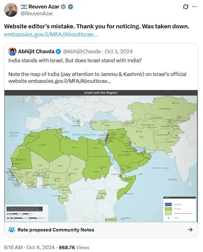
This is not the first time such cartographic insensitivity has invited criticism. In October 2024, Israel was compelled to remove a map from its official website after it was accused of showing Jammu & Kashmir as part of Pakistan. At the time, the Israeli embassy in India attributed the error to a “website editor’s oversight.”
But the recurrence of such incidents has raised eyebrows in New Delhi. Observers question whether Israel fully grasps the weight India places on territorial representation—or worse, whether it views such matters as expendable in the broader calculus of military messaging.
While the Indian government has so far refrained from issuing a formal statement, the public reaction has been intense, especially among right-wing digital communities. One popular handle commented, “Now you understand why India remains neutral. In diplomacy, you have no friends—only interests.” This sentiment underscores a broader disillusionment among certain sections of the Indian public, who view the episode as proof that strategic partnerships can often mask tactical disregard.
It is a reminder that diplomacy, particularly in the digital age, is no longer confined to foreign offices and formal communiqués. A single image—no matter how illustrative in intention—can ripple through domestic politics, media ecosystems, and public sentiment.
Israel, in this case, may have succeeded in warning the world about Iranian missiles, but in doing so, it failed to recognize that borders are not just lines on a map—they are lines that define trust.
❤️ Support Independent Journalism
Your contribution keeps our reporting free, fearless, and accessible to everyone.
Or make a one-time donation
Secure via Razorpay • 12 monthly payments • Cancel anytime before next cycle


(We don't allow anyone to copy content. For Copyright or Use of Content related questions, visit here.)

The Chenab Times News Desk

